https://blogger.googleusercontent.com/img/b/R29vZ2xl/AVvXsEjFcjDYcUXjKSjh9I75YkTYZ5-vc-t3CuhdoBHVy5XMb55-AKbc4NND71QWWvutZCD0xZYS2b4g3oL9f2Bj0WU4nJydn5oIHLmhlMeJUzx1jmXKBD3vpv0Q5Ag4zEQZ9pPeFfdW6_9y6d8/s1600/Qin+dynasty+map..JPG
(This map was not drawn or created by me, Credit to its rightful owner in full is essential due to copyright laws.)
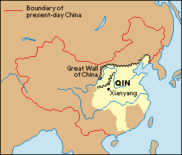
"The date, obviously dates from 221 to 207 B.C. Back in those times, life was hard. As stated, Qin had a large empire, the great wall ranging around nearly half of China, and it was no easy task to build. (Northern spike-like elements VIA Outline of lighter shaded map within the Qin dynasty.) Hundreds of thousands of workers became injured, ill, and/or died in the attempt which is why the Great Wall is unofficially called The Worlds Biggest Graveyard due to the amount of deaths prior to its completion. Compared to the modern day version of the Chinese map, this map relates to a small portion (Lightly shaded area inside the red outlined map.) As Qin stole from nobles, and there were very few with resource to fuel his thirst for land. The point of this map is to show how much land of China the Qin Dynasty took up. Not as much as how big China rages now (Unknown if size difference was took into contact back then.) But it still is a big chunk of it. (roughly 23% of overall China.)
No comments:
Post a Comment